
Since mid-September, the police have been taking back Kenscoff neighborhood by neighborhood, and for the first time since January 2025, they’re doing it in the right order.
Since mid-September, the police have been taking back Kenscoff neighborhood by neighborhood, and for the first time since January 2025, they’re doing it in the right order. To understand what that means, you have to follow the path the gangs take to rise to power, see where the police are along that path, and what’s left ahead of them.
On September 26, the Haitian National Police (PNH) announced they had full control of Godet, Viard 1, Viard 2, and Bois d’Avril (Le Nouvelliste, September 28, 2026). On the afternoon of October 6, they added Belot and the Montcel Hotel to the list. After two massacres in less than two months, these announcements were met with relief, and rightly so. But a list of reclaimed neighborhoods doesn’t mean much to those who don’t know where they are or what they’re worth. An announcement tells you what was taken; it doesn’t say if you’ll be able to hold onto it.To answer this question, you have to look at the terrain, because in Kenscoff it’s the terrain that decides: who sees whom, who gets there first, and what a post placed here instead of there can prevent. So this article starts at the very beginning. It describes the path gangs take, from the bottom to the top, naming along the way every feature of the landscape that will matter later. Once you have that path in your head, it’s easy to see what the police have actually gained since September, what’s still ahead of them, the three traps that this terrain sets for anyone holding Kenscoff, and what still needs to be done to properly give credit.A word before we start. Everything that follows is based on public sources: police press releases, the media, reports from the BINUH and RNDDH, and a field model. The police know things these sources don’t mention, and they may hold positions they don’t announce, which would be normal, by the way. So this article doesn’t judge what they do; it says what the field is asking for, and where public announcements stand, as of October 6, in relation to that. It’s up to them to say whether the gap is real or just apparent.
The road up, from Carrefour to Kenscoff
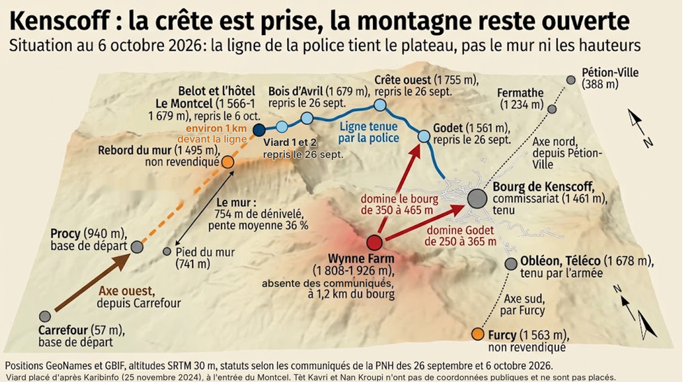
The gangs that attack Kenscoff almost all come from Carrefour, to the west. This has been clear since the first massacre: the BINUH report from April 2025 describes armed groups walking up from the plains, with donkeys loaded with ammunition. So let’s start there, and go up with them.Carrefour is in the plain, at an altitude of 57 meters. Over nearly nine kilometers, the terrain rises like a long hill, about 10% on average, tiring but without obstacles, up to around Procy, a small village perched on the slope, at about 940 meters. Just after Procy, the path drops into a ravine and goes back down to 741 meters. That’s where everything changes. From the bottom of this ravine rises a slope that gains 754 meters in just 2.1 kilometers. The average slope is 36%, and the last kilometer, the steepest, climbs to 40%. In this article, this slope is called the wall. It’s the first word to remember, because it’s the main obstacle between the gangs and the town.The top of the wall, where the slope suddenly stops, is at 1,495 meters. That’s the edge. Beyond the edge, the terrain changes completely: for about four kilometers, it’s almost flat, with barely a 6% incline, gradually going up. That’s the plateau. Belot starts very close to the edge: the Le Montcel hotel, which is part of it, is barely a kilometer from the edge, 80 meters higher. Viard 1 and Viard 2, two small villages, are at the entrance to Montcel (Karibinfo, November 25, 2024). Bois d’Avril is further along, around the middle of the plateau, at 1,679 meters.At the end of the plateau, the terrain rises one last time up to 1,755 meters. That’s the ridge, the highest point on the entire path, 3.8 kilometers from the town of Kenscoff. From the ridge, you go back down. First, you pass through Godet, a dip at 1,561 meters, wedged between the ridge on one side and another height, Wynne Farm, on the other. Then you reach the town itself and its police station, at 1,461 meters.The drawing above shows this path from the side, as if you were slicing the mountain: the long slope from Carrefour, the ravine at the foot of the wall, the wall, the ledge, the plateau, the ridge, the hollow of Godet, the village. The ridge is 1,700 meters higher than the plain, and nearly half of this height is gained over the two kilometers of the wall. Everything that follows is read from above.
There’s one last element to set up, and that’s the town itself. Kenscoff isn’t on a hill. The town is down below, surrounded by heights that tower over it: the western ridge at 1,755 meters, Obléon and its Téléco site at 1,678 meters to the north, and especially Wynne Farm, just 1.2 kilometers from the police station, at 1,808 meters for the farm and 1,926 meters for the antennas right above. From Wynne Farm, you’re 350 to 465 meters above downtown. On the profile, Wynne Farm shows up in red and Obléon in dark gray. Neither of them is on the gangs’ path, but the first overlooks both Godet and the town, and the second has the town right beneath it. This is what the article calls the bowl: the town at the bottom, three heights around the edges.Who keeps an eye on the edges sees the bottom. Before the massacre on August 23, gangs flew drones over the center for several days (RNDDH, report of September 16, 2026): not to discover the bowl, which they already knew, but to find out where the armored vehicles were.
Here’s the setting: a wall, a ledge, a plateau, a ridge, the hollow of Godet, and the bowl where the town is. With these six words, the September reports stop being just a list of names.What September changed
Let’s go back to the timeline and place it on the path. On September 13 and 14, gangs attacked Viard, at the entrance to Montcel; the attack was repelled. On the 16th and 17th, the police went on the offensive in Viard 1 and 2, Godet, Bois d’Avril, Nan Kroupi, Belot, and Tèt Kavri. On the 20th, six hostages were freed with the support of the Gang Suppression Force (Vant Bèf Info, September 22). On the 25th, Bois d’Avril was recaptured. On the 26th, the police announced full control of Godet, Viard 1, Viard 2, and Bois d’Avril. On October 6, Belot and the Le Montcel hotel were added to the list.Placed on the map, these names tell just one story. Godet is the dip just above the village. Bois d’Avril is on the other side of the ridge, in the middle of the plateau, and between the two is obviously the ridge itself. Viard is even farther, at the entrance to Montcel. On October 6, Montcel was added, a kilometer from the edge. In three weeks, the police retraced the gangs’ path in reverse, from the village to the edge of the plateau.This is the real progress of September, and it’s bigger than people say. Since January 2025, every time gangs went up, they found the state down in the village, and attacked from above. Today, an assailant who reaches the top of the wall finds the police a kilometer ahead, and higher up than him. It’s not just a little improvement, it’s a whole different situation. And since September 26, no attacks have been reported in the town. Ten days of calm is very little, we’ll see later why; but it’s the first time since July.What’s Ahead
The operation isn’t over, and that’s the first thing to keep in mind. In three weeks, the line has moved from Godet to Montcel; it’s still advancing, and Montcel was only announced on the afternoon of October 6. What we can do today is look at where it stands as of that date and what’s ahead of it. It’s at Montcel, at Belot. Ahead of it, about a kilometer away, is the edge of the wall. Tèt Kavri, which had been targeted since September 16, is near Viard: that’s where attackers had set out from to hit Viard 2 in June 2025 (Le Nouvelliste, June 12, 2025). Nan Kroupi doesn’t have a public position.Why does that last kilometer matter so much? Because the easiest ground to take is also the most useful to hold. Between Le Montcel and the edge, the terrain slopes gently. But whoever holds the edge forces the attacker to climb the 754 meters of the wall right in front of them, with nothing to hide behind, before they can take a useful shot. If someone stops a kilometer short, it lets them reach the top of the wall, catch their breath on the plateau, and pick their moment. So it’s the next stage that matters most, and if the line keeps advancing at September’s pace, it’s within reach.The second point concerns the bowl. Of the three heights above the town, one is certainly held: Obléon, where the army maintains a permanent post. The ridge is inside the reported line. That leaves Wynne Farm, the highest of the three and the closest to the commissariat. The police have already operated there on February 20, 2026, the same day as at Godet (Haitian Times, February 22, 2026); the September and October reports, which focus on the western axis, don’t mention it, which doesn’t mean it’s empty. It might be occupied without that being reported, or it could be next in the order of operations. The day the police say what’s going on, the residents who are hesitant to return will know what to expect.
The ledge in front, Wynne Farm above: those are the two places the future will have to tackle, and it’s too early to say they won’t. If the article stops here, it’s because the terrain of Kenscoff has already produced three similar situations, and they went badly. These are the pitfalls of the land. They can trap any force, even the best-intentioned, and knowing them in advance is better than recognizing them afterward.
First trap: the hollow of Godet
Godet is the locality most mentioned in reports since January 2025. Law enforcement has returned there five times in twenty months. Since November 2025, they come back on average every 99 days, and the two massacres this summer happened between two of these visits. A locality visited every three months is not really secured. It’s just visited.The terrain explains why. Godet is a hollow: the ridge on one side rises nearly 200 meters above it, and Wynne Farm on the other, 250 to 365 meters. A position at Godet is a post at the bottom of a small bowl, seen from both sides at once. You cross a hollow; you can only hold it by holding the two heights on each side. Each time there was a return to Godet, the reports announced the recapture of the hollow; none said whether the edges were then held, and it’s possible they were for a time. What the series of five returns shows is only that what had been put in place didn’t hold in between. The same reasoning applies to the village: holding the police station without holding Wynne Farm is like holding the bottom of the big bowl while leaving the edge open to whoever wants to take it.Second trap: the race to the ridge
In the mountains, the one at the top has the advantage, on one condition: to be in place before the other arrives. So, an attack on Kenscoff is first of all a race. On one side, the attackers who are climbing from the foot of the wall. On the other, the police reinforcements who set off from the town, where the station and supplies are located. The finish line is the ridge: the highest point of the path, the one that controls both the plateau and the Godet hollow.
This race can be measured. You just have to count like hikers: one hour for five kilometers of walking, plus one hour for every 600 meters of climbing. The attacker starting from the foot of the wall has 6.3 kilometers to cover and over 1,000 meters to climb: it will take him about three hours. The policeman starting from the town has 3.7 kilometers to cover and 360 meters to climb: one hour and twenty minutes. On paper, the police therefore have an hour and forty minutes head start, as shown by the first two bars of the graphs.